Richard Engelmann: Sprachminderheiten im Gebiete der ehemaligen Österreich-ungarischen Monarchie (ohne Bosnien-Hercegovina). 1:200 000. Vienna, 1919, Militärgeographisches Institut. 92 sheets, each are cc. 57 × 38 cms. (The georeferenced map is accessible here.)
In this series of articles, we publish large, multi-sheet, georeferenced maps that represent the ethnic composition of areas within the region that was called Zwischen Europa, Central Europe or East-Central Europe after World War I. We publish these in a way that all available sheets of each map series may be viewed simultaneously. Due to their size and rarity, these maps have hardly been fully accessible on the internet. The maps presented here were typically background material prepared for the delegations during the peace treaty negotiations or for negotiations that concerned revision of borders. Thus, they were often manuscripts. The maps themselves are available on mapire.eu, which is the cartographic website of the Arcanum Database Ltd. Descriptions of maps related to the peace treaty negotiations after World War I are available on the website of the Trianon 100 „Momentum” research group, while maps prepared during World War II will be available on horizontok.hu, the online journal of the Institute of Central Europe of the József Eötvös Research Centre, National University of Public Service (Hungary). Gábor Timár referenced the maps while Dániel Segyevy carried out the research and prepared the descriptions.
The Treaty of Saint-Germain1, signed on 10 September 1919, was the one among the Paris treaties following World War I that formally ended the war between the Entente powers and Austria. The Austrian half of Austria-Hungary, which was also called Cisleithania actually consisted of several different areas. During the final days of World War I, a number of nationalities declared their secession from the defeated Austria-Hungary. Charles I, the Emperor of Austria (and King of Hungary with the name Charles IV) abdicated, and in November 1918 Austria, Czechoslovakia and Hungary declared that they were republics and aș a result the institutions of the empire and kingdom ceased to exist. The German-Austrian Republic (Republik Deutschösterreich) – the predecessor of the Republic of Austria – comprised the German-speaking areas of Cisleithania. The primary objective of the leaders of the state was unification with Germany. However, this did not become reality and the Austrian and German peace treaties explicitly banned such a move.
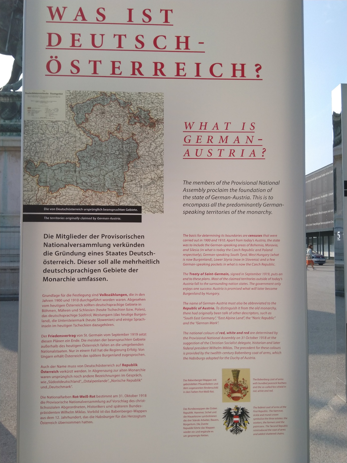 Open-air centenary exhibition in Vienna, Heldenplatz, Autumn of 2018 (Photographed by the author)
The map discussed here is a product of the Austrian Statistical Office. Only a few copies were made under the guidance of Richard Engelmann in the summer of 1919. The map was based on the census of 1910 and represented the linguistic composition of the former Austria-Hungary in 92 sheets. These are based on 1:200 000 scale sheets of the general map of Central Europe. The series of sheets was part of the material prepared for the Austrian delegation to the peace treaty negotiations, however, they did not have the opportunity to present it. We do not find many references to the map in current literature. Ingrid Kretschmer2 and Petra Svatek3 discussed it briefly.
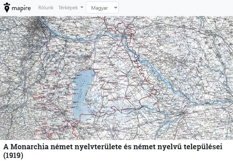 The georeferenced map. Location: Humboldt Universität zu Berlin Geographisches Institut Kartensammlung B-2253-333-02.
A few copies of this map are available in Vienna and Berlin. The copy we used for georeferencing is from Berlin and it is particularly interesting because it is located in the map collection of the Department of Geography of the Humboldt University thanks to Albrecht Penck who also worked at the University of Vienna until 1911. In the post-war years he was already teaching in Berlin and was also the director of the Institute of Geography and Oceanography of Berlin. In his latter quality, he also edited and coordinated the production of a multi-sheet map representing ethnic patterns. This represented the ethnic situation of the area that was to become the Polish-German border zone. Soon we will publish this latter work in georeferenced format on the Mapire interface.
The map discussed here used unique techniques for representing data. Regarding those of native language it does not provide a complete picture, moreover, – although it has a consistent logic – it is rather patchy. It only shows the German minority for the Hungarian Kingdom, while in the Austrian part we only see data for German-Austria and only for the non-German speaking minorities. There is no representation of other areas that used to be under Austrian domination.
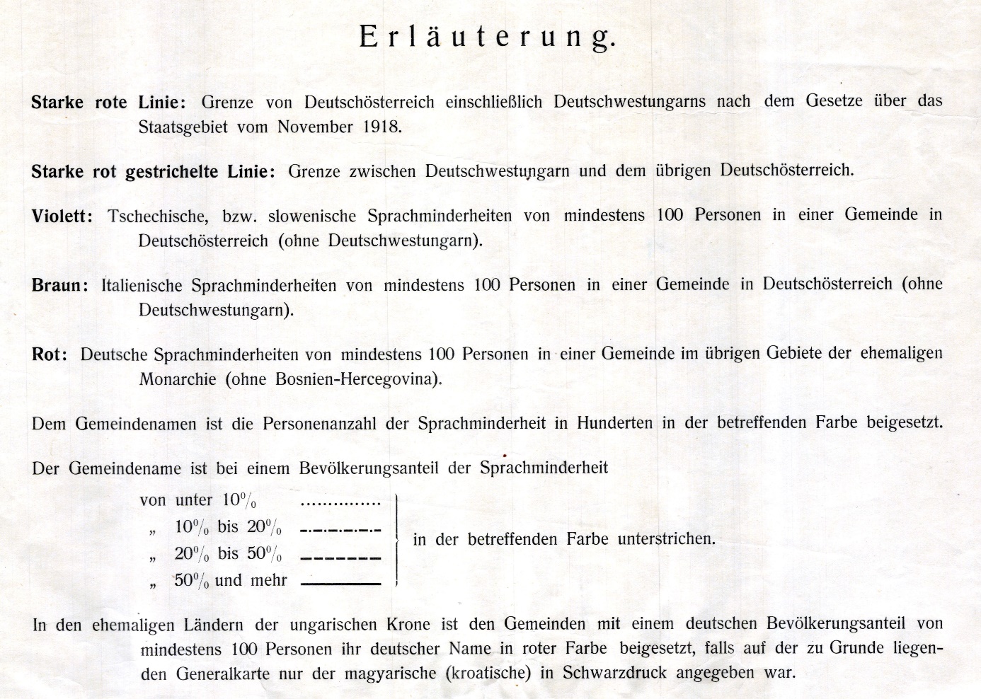 Richard Engelmann: Sprachminderheiten im Gebiete der ehemaligen Österreich-ungarischen Monarchie (ohne Bosnien-Hercegovina) 1919. (Legend) Location: Humboldt Universität zu Berlin Geographisches Institut Kartensammlung B-2253-333-02.
The editor of the map underlined the name of locations in some manner (dotted, dash-dotted or solid line) and provided the absolute figure of the given minority in hundreds behind or below the name of the location. The colour of the underlining and of the number referred to the particular minority (red referred to Germans in the Hungarian Kingdom, purple meant Czechs or Slovenians in German-Austria, brown stood for Italians in German-Austria). The type of underlining chosen expressed the proportion of the given minority (dotted line: below 10%, dash-dotted line: between 20% and 50%, solid line: above 50%) Since in these divisions 51% and 100% look the same while lower percentages appear more differentiated, lower proportions are overrepresented, overall. This is especially given so that the font size of labels is all the same. Due to the usage of red this makes the German minority in Western Hungary (Burgenland) look quite prominent.
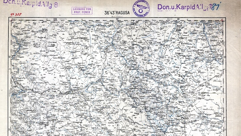
We did not reference the sheet for Dubrovnik (Ragusa) as it stands separate from the other sheets. However, we publish it here:
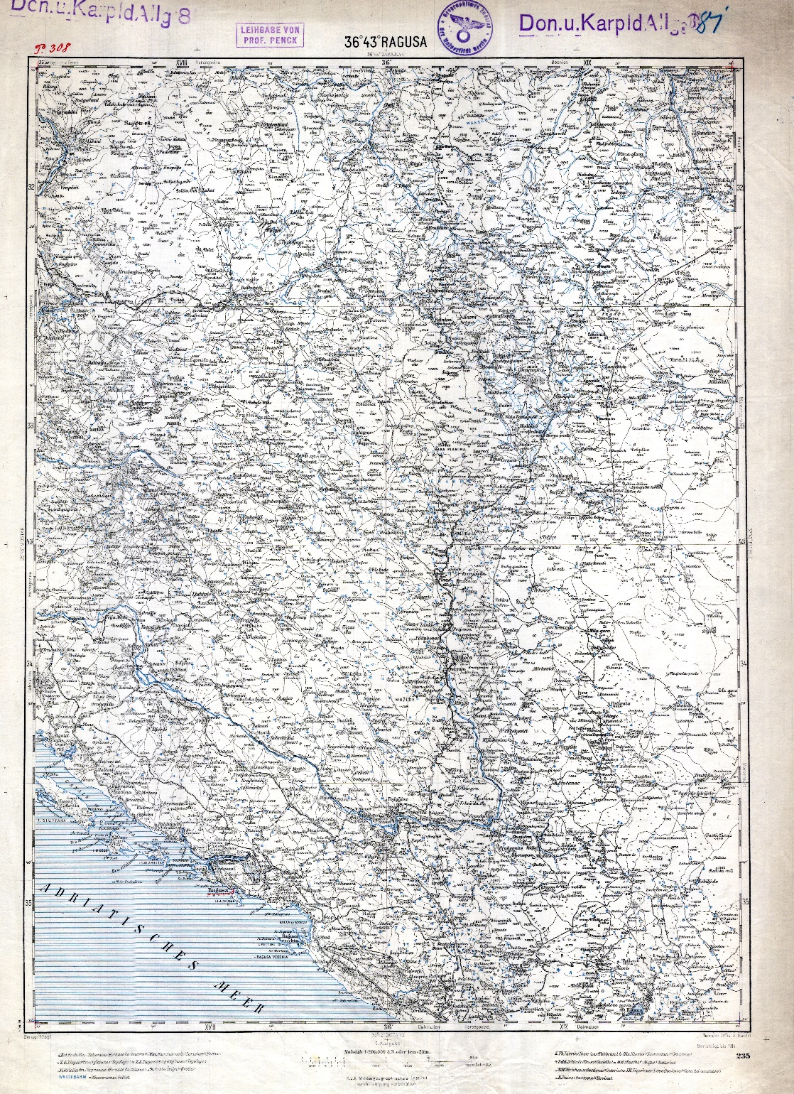 Richard Engelmann: Sprachminderheiten im Gebiete der ehemaligen Österreich-ungarischen Monarchie (ohne Bosnien-Hercegovina) 1919. Ragusa (Dubrovnik) sheet. Location: Humboldt Universität zu Berlin Geographisches Institut Kartensammlung B-2253-333-02.
Dániel Segyevy (University of Leipzig, Graduate School for Global and Area Studies, Leipzig; Institute of Central Europe, József Eötvös Research Centre, National University of Public Service, Budapest)
We are grateful to Gerd Schilling, the Head of of the Maps Collection of the Department of Geography of Humboldt University for digitalizing the map and for providing us with the digitalized copy.
Translated from Hungarian by Róbert Balogh.
1:Text of the Peace Treaty of Saint-Germain, source: Centre des Archives diplomatiques du ministère des Affaires étrangères, Párizs, Traité de paix entre les puissances alliées et associées et l'Autriche (dit "Traité de Saint-Germain"), accord signé ou adopté le 10/09/1919.
2: Kretschmer, Ingrid: Frühe ethnographsiche Karten Südosteuropas aus Wien. In: Zentai László – Győrffy János – Török Zsolt Győző (eds.): Térkép – tudomány : tanulmányok Klinghammer István professzor 65. születésnapja tiszteletére. Studia Cartologica 13. 2006. 259–266.
3: Svatek, Petra: Ethnic cartography and politics in Vienna,1918–1945. In: British Journal for the History of Sience, March 2018, 99–121.
4: Heyde, Herbert: Karte der Verbreitung von Deutschen und Polen längst der Warthe-netze-Linie und in Westpreußen. Berlin, Universität Berlin, 1919, Geographisches Institut. 43 sheets, 33 × 38 cm each, on average.


